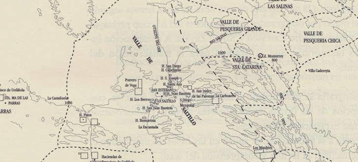
The following map contains a visual representation of old Jurisdictions for Northeastern New Spain that will help you along while doing your research.
It is titled “Land Grants, Farms, Villages, Villas, and Cities in the Northeast of New Spain” means in Spanish (Mercedes de Tierras, Haciendas, Pueblos, Villas y Ciudades en el Noreste Novohispano).
In the book “Libro del Cabildo de la Villa de Santiago del Saltillo”, (Book of the Council of the Village of Santiago del Saltillo), I came across a very interesting map that I know you will enjoy.
I am sharing it with you here since I know that it will help you estimate where your ancestors were from, it will not pinpoint their exact place but give you an idea.
The way to use the map is to become familiar with the valleys that it mentions. These are ancient jurisdictions that will help you find records the further back you go in your research.
Use the towns mentioned in the map to estimate where your ancestors lived. The mentioned cities and towns would be the first place to search for records about them.
This image shows you an estimated location of where the following areas were located:
- Valle de Boca de Leones
- Valle de Coahuila
- Valle de las Salinas
- Villa Cerralvo
- Valle de Pesqueria
- Valle de Parras
- Saltillo
- Valle de Buena Esperanza
- Valle de Mazapil
- Valle de Pesqueria Grande
- Valle de Santa Catarina
- Villa Cadereyta
It also lists many more villas, towns, and haciendas.
Land Grants, Farms, Villages, Villas, and Cities in the Northeast of New Spain:
I hope that this map comes in handy to you as it has come in handy to me.
Other Posts That May Interest You
1858 and 1886 Maps of Nuevo Leon, Mexico
Source:
Garza, Valentina Martinez, and Perez, Juan Manuel Zevallos. Libro del Cabildo de la Villa de Santiago del Saltillo 1578 – 1655. 2002, Pg 52
Note: Originally posted on April 2, 2014, and last updated on 2-12-2024


Thank you soooooo muchisimo!!
Thank you. This will be a great help.
Esperiqueta , Flores , Salinas , Morin, Barrera